History of Geomancy – A Long Time Ago
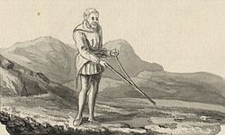
THE PRACTICE OF GEOMANCY
‘GEOMANCY’ derives from the Greek words GE, earth, and MANTEIA, divination or prophecy.
There has been an oracular divinatory tradition of geomancy in use for millennia across Arabia, Africa, Europe and Asia.
In some cultures and periods of history the term geomancy has referred to a divinatory system whereby foretelling was done principally by some method of sand or earth casting.

Divination with Corn Kernels
For many other cultures geomantic practices have also involved direct contact with earth energies, astronomical alignments, sacred geometry, spirit realms, sacred mountains and holy wells etc. as ways of understanding, living in and manipulating the environment. For them geomantic knowledge was employed as an art and science for better living, dying and worship.
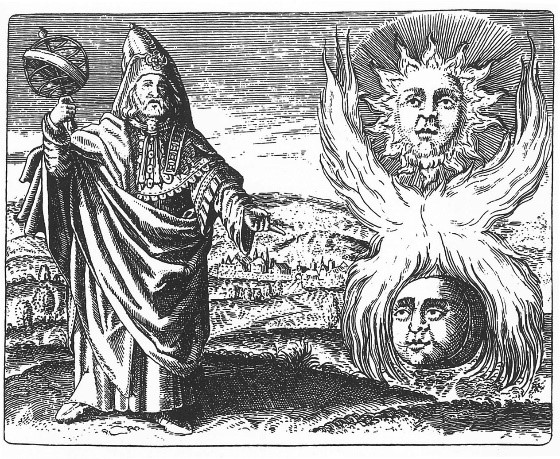
Hermes with the Sun and Moon
These two streams of geomancy have been practised widely and often concurrently. However, it is to the earth divinatory method that the word ‘geomancy’ was first applied.
GEOMANCY AS EARTH DIVINATION
The earliest styles of divination involved reading cracks in the ground, throwing handfuls of earth onto the ground, striking the sand with a stick to create random patterns, or randomly drawing a number of stones, seeds, or roots, and recording the odd or even numbers of dots generated as a single or two points respectively. Performing this four times generates one of sixteen binary tetragrams – the geomantic tableaux – each with associated meanings and astrological correspondences. The top line of one or two points is the ‘head’, of the fire element, the second line the ‘neck’ – air element, the third line the ‘body’ – water element, and the bottom line the ‘feet’ – earth element.
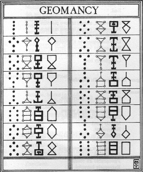
A Geomantic Tableaux of Sigils, Source Nigel Pennick.
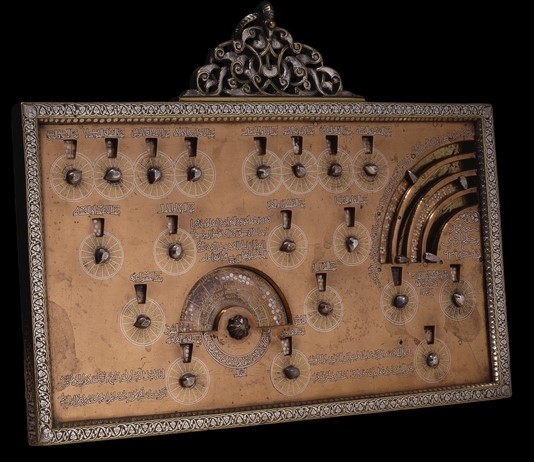
Al Mawsili – Arabic Geomancy board (British Museum)
African Origins
Tradition ascribes an African origin to geomantic divination. An eight-fold system of divination was practised in pre-dynastic Egypt (fourth millennium BCE) which is identical to the West African Ifa oracular tradition. A derivation of this is the Sixteen Cowries system practised in West Africa and the Americas.

Wooden Yoruba Divination Plate for Responses from the Oracle of IfaIn India Geomancy is called Ramal Shastra.

Ramal Shastra Dice

Later Norse Futhark
From the Arabic to Europe
The main knowledge of geomancy, as a divinatory art, came to Europe via Arabic texts in the 12th century in Spain, and from there spread across Europe. The Byzantines also called it Rabolion or Ramplion.
In fact the word geomantia (earth divination) was a direct translation from the Arabic khatt al-raml (sand writing), also known as ‘ilm al-raml (science of the sand) and darb al-raml or zarb al-raml (striking the sand). This last name came from the practice of hitting the sand several times with a stick to read the patterns left behind to decide whether one or two points.

Meteorological Divination by Robert Fludd
Middle Ages and Renaissance
In Europe the divinatory system was widely practiced during the Middle Ages and Renaissance, and in the latter period Henry Cornelius Agrippa, Robert Fludd and John Heydon wrote significant works on this divination method, drawing on medieval and European and Arabic works on the subject, in which the basic techniques of geomantic divination had been expanded and applied in a vast range of ways, incorporating many astrological elements.
The word ‘geomancy’ during this period referred to this specific method of divination using sixteen figures formed of four lines of one or two points.

A Geomantic Wheel of Opposites

European Geomantic shield

European Anatomical correspondences, Source Nigel Pennick
Geomancy is Integrated with Astrology
In Madagascar, this microcosmic divinatory system, known as Sikidy, is integrated under the title Vintana or ‘Fate’ with astrology and a macrocosmic geomancy that incorporates sacred wells, caves, cairns, standing stones and traditional straight trackways.
Queen Ranavalona I of Madagascar was cited by missionaries as the epitome of ‘superstition’ as she employed Mpisikidy (geomancers) to define her every move, perhaps the last of the sacral monarchs who lived entirely according to the ancient canonical way of life. She would only perform the correct acts of the day, observed the lucky and unlucky colours of the day, sat in the correct place in the palace for the hour and day, and journeyed only to those places geomantically correct for the astrological aspects of the time.
GEOMANCY – EARTH WISDOM FOR LIVING
Probably the oldest geomantic traditions currently extant, perhaps dating back 100,000 years, are those of palaeolithic and mesolithic Aboriginal Australia.

Aboriginal Shaman at Work
Knowledge of local landscape for practical survival reasons such as food, shelter and route finding is intertwined with traditions of landscape creation by Dream-time ancestors, local landscape spirits, sacred sites, cave paintings and ‘song-lines’ across country.

Songlines Around Uluru
Integral to this knowledge is their proper location-specific and timely ceremonial use for earth magic purposes such as fertility and abundance of food, for education, to maintain the spiritual integrity of the sacred sites and song-lines, and ensure the harmony of the people with their environment and each other.
The neolithic and bronze ages have left a wide legacy of sacred sites across Europe, Asia, Africa and the Americas that reveal in their design advanced knowledge of geomantic precepts.

Triple Goddess Represented in the Design of Silbury in Whiltshire
Megalithic temples and processional routes, standing stones and stone circles, pyramids, conical mounds and chambered cairns show evidence of a widespread and consistent understanding of sacred geometry and metrology, astronomical alignment to sun, moon and star rising and setting orientations, leylines, global geomagnetic grids, and underground water veins.

Callanish Stones on Isle of Lewis
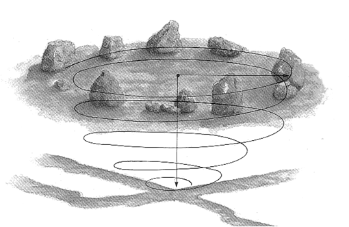
Underground Stream Crossing Beneath Stone Circle

Spirial Sacred Space Design
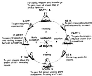
Cheyenne Medicine Wheel (Source: Alan Bleakley)
Eastern Geomancy
Indian culture has developed a corpus of geomantic knowledge known as Vaastu that may date back to 6000 B.C.E. and was well developed by the time the cities of Harappa and Mohenjo-Daro emerged in the Indus Valley civilisation around 2600 B.C.E.
The Rig Veda (c.2000-1500 B.C.E.) contains early references, and the Vastu Shastras (from 600 C.E.) are Sanskrit manuals for constructing palatial temples and included chapters on home construction, town planning, and how efficient villages, towns and kingdoms integrated temples, water bodies and gardens within them to achieve harmony with nature.
Astronomy, astrology, earth energies, Hindu religion and magic and the science of yantra (geometry) and mantra are woven together to create a cohesive set of architectural precepts for the design of both sacred and secular spaces.
Feng Shui – A Long History of Geomantic Knowledge.
Chinese culture, philosophy, religion and ancient science embodies geomantic knowledge now known as Feng Shui. The earliest archaeological evidence of this is found in the Yangshao and Hongshan neolithic culture sites dated to 5000 B.C.E.
The Ba Gua or Eight Trigrams, a fundamental cycle of both time and space in Feng Shui attributed to Fu Xi (c.3300 B.C.E.), are identical to the Eight-fold Druid Wheel of the Year, suggesting a common origin of metaphysical tradition.
The Ho Tu magic square is also ascribed by tradition to Fu Xi, and the Lo Shu magic square to Wen Wang in 2205 B.C.E. The sixty-four hexagrams of the Yi Jing (c. 1150 B.C.E.) are an elaboration of the trigrams from yin-yang, a parallel development to the sixteen tetragrams of Arabic / African / European tradition.
The earliest written reference to Chinese geomantic practice dates back to Emperor Da Yu (c. 2200-2101 B.C.E). Cosmography, astronomy, astrology, numerology, earth energies and landscape topography are woven with Confucian wisdom and Daoist magic into a body of architectural and landscape design as well as ceremonial practice that are used in the design of sacred, governmental and secular buildings and landscapes.
Feng shui is a geomantic tradition that includes written records forming the largest and oldest body of texts on the subject. It has a long continuity of practice, and while some feng shui practices have evolved over time with changes of environment and needs, the original precepts are still very much part of contemporary practice.
Classical Period
The legacy of iron age architecture is characterised more by defensive forts that utilise natural topographical features to create places of sanctuary in troubled times, though there is also clear evidence that Celtic cultures establishing political tribal capitals and chose their battlegrounds according to a well-defined geomantically-devised grid system across Europe, and that the Druid colleges of learning were sited at places of geomantic significance.
The Greco-Roman period shows evidence of geomantic design everywhere in the architecture and siting of temples and palaces, as well as wise words from Hesiod (c.700 B.C.E) who instructs us “do not relieve yourselves into sacred springs”.
The ancient Greek schools of learning had links with the later Druids through the Pythagoreans, and documented the geomantic geometry long known to the oral adepts. Euclid’s Sacred Geometry (c. 300 B.C.E.) codified much of this prehistoric knowledge, which was in turn transmitted into the Arabic culture through the Alexandrian library. This is brought alive in the architecture of mosques, and then brought to Europe by the Moors to flourish in medieval Gothic church architecture.
The Romans noted, in their conquest of the Etruscans, standing stones set in linear patterns over the entire countryside of Tuscany.
Romans also record discovering these ‘straight tracks’ in almost every country they subjugated: across Europe, North Africa, Crete, and the regions of ancient Babylon and Nineveh. Roman roads follow these earlier roads, themselves often aligned along global geomagnetic grid-lines.
The Normans and Beyond in Britain
In Britain the conquering Normans, like the Romans before them, employed geomancy to maintain their royal/imperial power, and the royal families and religious institutions of Europe and elsewhere have continued to employ geomancy to assert control and peace over countries.
An example of this is the supplanting of Saxon conical church towers with Norman square crenellated towers of political / religious dominance.
The Middle Ages
The medieval stonemasons’ work encodes geometry, metrology, acoustics, astronomy, earth energies, mythology and magic in the great Gothic Cathedrals of Europe. The landscape was significantly redesigned using geometric principles in the middle ages by the Cathars, Knights Templar and the Holy Church of Rome.
In his 1538-43 ‘Itineraries’ Henry 8th’s antiquarian surveyor John Leland enquired of Morris dancers from where their inspiration came for the complex dances they performed, to be told ‘from the mysterious grass circles that appear in our fields in summer-time’.
18th Century – A Druidic Revival
In 1740 the antiquarian Dr. William Stukeley first noted that the axis of Stonehenge and the Avenue leading from it point to the north-east, ‘whereabouts the sun rises when the days are longest’.
He perceived the whole British landscape as laid out according to a sacred ‘druidic’ pattern, and etched with symbols of serpents and winged discs such as at Avebury.
At Barrow near Hull he found a great earthwork representing a winged circle, its trenches arranged so as to measure the seasonal tides of the Humber Estuary, and found another near Navestock Common in Essex ‘…They have made plains and hills, valleys, springs and rivers contribute to form a temple three miles in length…They have stamped a whole country with the impress of this sacred character’.
He was active in the druid revival (which began in 1717 along with a number of other magical societies) which returned to performing ceremony at the old Neolithic and Bronze age sacred sites.
The 20th Century – The Earth Mysteries are Rediscovered
The twentieth century saw a burgeoning of interest in Europe in rediscovering the geomantic mysteries of the past.
The archaeoastronomer Norman Lockyear explored astronomical alignment and sacred geometry at sacred sites in Greece, Egypt and Britain in the late eighteen and early nineteen hundreds, and found alignments such as the Ley running from a round barrow north of Stonehenge near the cursus, through Stonehenge, Old Sarum, Salisbury cathedral and two further Iron age hill-forts.
In the 1920s Alfred Watkins first became aware of the alignment of ancient British sites in the early 1920’s, in what he described as ‘a flood of ancestral memory’. He coined the term Ley to describe these paths across the landscape that include mounds, long-barrows, cairns, cursus, dolmens, standing stones, mark-stones, stone circles, henges, water-markers (moats, ponds, springs, fords, wells), castles, beacon-hills, churches, cross-roads, notches in hills, camps and hill-forts.
Joseph Heinsch and Wihelm Teudt echoed this research into Holy Lines and astronomical aligments in the landscape in Germany, both published in 1929.
Reginald Allendar Smith’s major contribution to the Earth Mysteries field was to first publish articles in the British Society of Dowsers journal in the 1930s reporting that he was consistently finding water under the same ancient sacred sites that were exciting the Ley hunters.
The engineer and archaeoastronomer Alexander Thom published between the 1950s and 1980s a vast body of research into the astronomical alignments of neolithic sacred sites across Britain, Ireland and France.
He showed through vigorous research that the length of 2.72 ft – the Megalithic Yard – was a common unit of measurement in the geometry of many megalithic monuments.
He also found a smaller common unit of measurement in the spiral carvings on certain megaliths and concluded that the megalithic builders were sophisticated astronomers engaged in a detailed study of the movements of the heavenly bodies, incorporated into their structures over a long period of observation.
Modern Era – Geomancy for Health
Baron Gustav Freiherr von Pohl did extensive research into geopathic stress in the 1920s and1930s and kick-started modern research into the links between negative earth energies and disease. He repeatedly found a 100% correlation between the location of beds of people who had died of cancer and the paths of ‘black streams’ under their homes.
Pierre Cody corroborated von Pohl’s findings in France in the 1930s, as did Joseph Wurst and Jacob Stangle in Germany in the 1950s.
In the 1960s and 1970s European researchers Hartmann, Curry, Wittman, Schneider, and latterly Schneck and Merz have made significant contributions to the understanding of a series of geomagnetic grids that cover the earth’s surface and have implications to health as well as the location of sacred sites.
CONTEMPORARY GEOMANCY IS BORN
John Michell, in his “View over Atlantis” of 1969, was the first contemporary writer to use the term ‘geomancy’ to embrace both the microcosmic divinatory system and the whole macrocosmic field of ‘earth mysteries’.
This use of the term was then picked up by Paul Screeton, editor of ‘The Ley Hunter’ magazine, and Nigel Pennick and Anthony Roberts, founders of the Institute of Geomantic Research.
Since the late 1960s the expanded definition of the term Geomancy has come into general use.
A new global eclectic geomantic discipline is evolving which incorporates, in addition to the microcosmic divinatory system, the macrocosmic context of leylines and other dowsable earth energies, planetary-wide topographical engineering and hidden patterns embedded in the landscape, the design of megalithic and temple structures and other sacred spaces, sacred geometry and metrology, astrology and astronomical alignment, as well as religious and magical ceremonial usage.
This includes local folk magic traditions as well as the large corpus of geomantic wisdom to be found enshrined in the precepts of Hindu Vaastu, Daoist / Confucian Feng Shui, Native American Medicine Wheel teachings, and other global cultural traditions.
In addition to these classical subjects of the earth mysteries schools, contemporary geomantic practice now also includes the new sciences of baubiologie, geobiologie, solar design and green architecture, and of necessity technopathic stress.
CONTEMPORARY GEOMANCERS
Besides John Michell’s enormous contribution to our understanding of geomancy today, other notable recent and contemporary researchers into various aspects of the field include Keith Critchlow, Robin Heath and John Martineau (sacred geometry and astronomy), John Neal (metrology), Guy Underwood, Paul Devereux, Tom Graves, Michael Poynder, Colin Bloy, Billy Gawn, Sig Lonegren, David Furlong, Hamish Miller and Paul Broadhurst (dowsing and working with earth energies), Bruce MacManaway, Rolf Gordon, Kathe Bachler, Marko Pogacnik, Patrick MacManaway and Richard Creightmore (geopathic stress), Jeff Saward and Marty Cain (labyrinths), and Ivan MacBeth (stone circle creation) – all are well worth reading.
REFERENCES
John Michael Greer, Earth Divination Earth Magic, 1999
Anthony Roberts, Geomancy – A Synthonal Reappraisal, 1981
John Michell, The View over Atlantis, 1969
Nigel Pennick, The Oracle of Geomancy, 1994
Graham Robb, The Ancient Paths: Discovering the Lost Map of Celtic Europe, 2013
Norman Lockyer, Stonehenge and Other British Stone Monuments Astronomically Considered, 1906
Alfred Watkins, Early British Trackways, Moats, Mounds, Camps and Sites, 1922
Alfred Watkins, The Old Straight Track: its mounds, beacons, moats, sites, and mark stones, 1925
Baron Gustav Freiherr von Pohl, Earth Currents – Causative Factor of Cancer and Other Diseases, 1932

